$XPLANET_CONFIG/scripts/xplanet.sh earth
cd $XPLANET_HOME/images
ln -s $XPLANET_CONFIG/images/clouds/clouds-4096.jpg clouds-4096.jpg
ln -s $XPLANET_CONFIG/images/lights/earth_lights_4800.tiff lights.tiff
ln -s $XPLANET_CONFIG/images/bump/gebco_08_rev_elev_21600x10800.png bump.png
ln -s $XPLANET_CONFIG/images/specular/specular.png specular.png
The script proceeds to call itself, but with a different function to run. The purpose of the earth function is to select the map file matching the current month.
MONTH=$(date +%m)
LAND_FILE="$EARTH_MAP_PRE.2004$MONTH.3x5400x2700.png"
ln -sfn $XPLANET_CONFIG/images/$LAND_FILE $XPLANET_HOME/images/earth.png
The images included with Xplanet are fine, but there are higher resolution maps that provide a lot more clarity and detail. It can also layer different kinds of maps on one another that provide a lifelike composite final image.
There are a number of websites where you can grab various images, and a small selection is on the Links page.
NASAs Blue Marble Next Generation site is an excellent resource to get complete, up to date, and high quality images. In fact, the repo includes their Earth map, night time map, and bump map.
The $EARTH_MAP_PRE parameter is set in xp.def. It’s actually in there three times pointing to three different directories. Each directory holds a different flavor of map, with more detail below. You can choose the type of earth map to use by commenting out the other two and uncommenting the one you want.
The setup then continues after linking to the Earth map and links to the other maps that will layer on: cloud, nighttime, bump, and specular.
Earth (Land) Maps
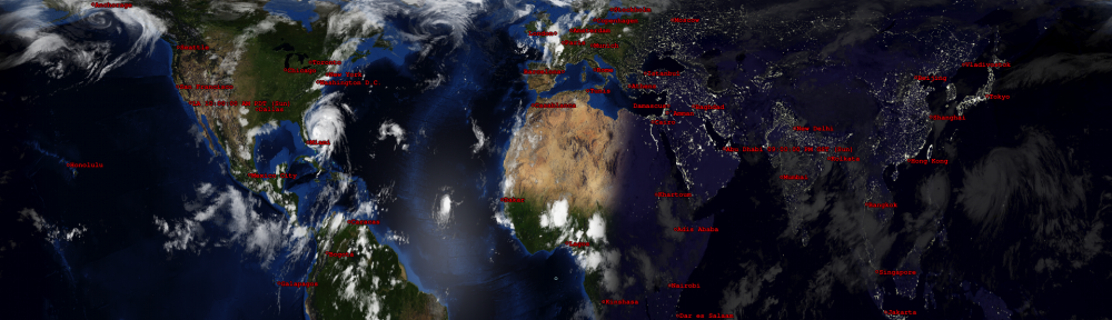
The Earth, of course, forever changes and has its own cycles, yearly and otherwise. Instead of using a static image of the Earth representing its geography, I prefer to show Earth going through its yearly cycle. Blue Marble Next Generation has three pages dedicated to Earth’s monthly imagery. There is a sense of the Earth inhaling and exhaling when cycling through the monthly images. The seasonal changes to the land through the greening and browning periods and the incoming and outgoing snow line shows us that Earth is very much alive.
Each month has three types of images: the monthly composite, the monthly composite with topographical information, and the monthly composite with topographical and bathymetric information.
Night Time Maps (City Lights)
The night time map represents, more than any other map, the story of us. The other maps tell the story of the Earth through its geology and its relationship to the Sun and Moon. The night time map tells our story – encapsulating our intended and unintended development – in an image that shows how we have adapted to control our place.
There are two maps from Blue Marble that I am partial to and I’ve included:
- Night Lights 2012 – Image using data gathered from 2012 using more advanced imaging techniques.
- Earth’s City Lights – Image using data from Oct 1994 through Mar 1995. The brightest areas are the most urbanized, and not necessarily the most populated. I prefer this map because I think it shows better, e.g., the outline of the Trans-Siberian railway and the Nile River are more apparent. Even China from 25 years ago is better highlighted in this image.
Bump Maps
A bump map is a type of topographical map representing the elevation of Earth’s land surface relative to sea-level. It provides relief shading which adds a sense of depth to the final image. It’s to your eyes what a raised terrain globe is to your fingers when you move across the land.
Specular Maps
Xplanet uses specular maps to display the reflection of the sun off the oceans. Tracking the sun’s reflection from East to West helps add a sense of realism to the composite.
The specular map from Celestia Motherlode is the best I’ve seen. The map came as a series of 512×512 images that I organized and stitched together using ImageMagick’s montage function.
Cloud Map
The cloud map is similar to the night time map. Massive cloud formations across the ocean being pushed by the trade winds, storms forming in the middle of the ocean, and regular weather patterns all come together and provide a sense of the present.
Here are a couple options to incorporate cloud maps:
- Blue Marble Clouds – High quality image, but static. This image will not realistically represent current weather patterns.
- Xeric Design Subscription – You can also subscribe to receive higher quality images. These cloud maps are updated every three hours and are near real-time. The benefit of subscribing is that the cloud formations accurately track to storms, typhoons, and hurricanes in real-time.
If you enjoy what Xplanet provides, consider a yearly subscription at your preferred resolution. It does absolutely make a difference in the rendered image.